Ten Peaks: Fantekjerringkollen
Høyde / altitude: 246 m.o.h.
Høydemeter /climb: 150 m
lengde /length: ca 6 km
5. september tok vi turen til Fantekjerringkollen i Gulsetmarka. Her har vi vært flere ganger før blandt annet; 2011, 2015 og 2017. Vi hadde tenkt å ta turen inn til Tvittingen, men det ble litt fortere skumring da vi tok turen etter at jeg hadde vært på jobb, så det får bli en annen gang.
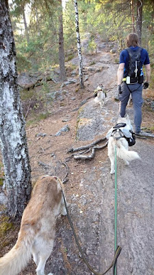
Turen er en fin tur, men med noen ganske så bratte partier på vei opp og ned fra toppen. Det var spesielt utfordrende for hundene med kløv, som denne dagen var Huldra, Orca og Såga.
The 5th of September we went for a hike to Fantekjerringkollen in the Gulset area. We've been here several times before, among them; 2011, 2015 og 2017. This time we planned to hike in to Tvittingen, but it started to go dark a bit sooner than we hoped as we started the walk after I had been to work. Tvittingen will have to wait for another time.
This is a nice hike, but with some steep parts on the way up and down from the peak itself. It was in particular challinging for the dogs with backpacks. This day Huldra, Orca and Såga carried backpacks.
Toppunktet kommer ganske tidlig på denne turen, men det er flott utsikt herfra og som en bonus så er resten av turen lettere å gå.
The peak is fairly early in this hike, but there is a nice view from Fantekjerringkollen, and as an added bonus the rest of the hike is easier to walk.
Down steep slopes it is nice to have dogs who has learnt the command "walk behind". It happens that they try to walk past you, but most of the time they are pretty good to stay behind in steep slopes and hills.
Further on it is a lot more level terrain, and we went by the peak Solifjell and the marsh Omdalsmyr, but not all the way to Tvittingen, before we turned back towards Gulset.
The last part towards the parking is on a gravel road. All in all this is a nice hike, and most likely we will visit the area several times more. Next time we'll try to get an earlier start so we'll be able to walk further into the woods.
 |
| Orca med kløven på Fantekjerringkollen Orca with his backpack at Fantekjerringkollen |
Høyde / altitude: 246 m.o.h.
Høydemeter /climb: 150 m
lengde /length: ca 6 km
5. september tok vi turen til Fantekjerringkollen i Gulsetmarka. Her har vi vært flere ganger før blandt annet; 2011, 2015 og 2017. Vi hadde tenkt å ta turen inn til Tvittingen, men det ble litt fortere skumring da vi tok turen etter at jeg hadde vært på jobb, så det får bli en annen gang.
Turen er en fin tur, men med noen ganske så bratte partier på vei opp og ned fra toppen. Det var spesielt utfordrende for hundene med kløv, som denne dagen var Huldra, Orca og Såga.
The 5th of September we went for a hike to Fantekjerringkollen in the Gulset area. We've been here several times before, among them; 2011, 2015 og 2017. This time we planned to hike in to Tvittingen, but it started to go dark a bit sooner than we hoped as we started the walk after I had been to work. Tvittingen will have to wait for another time.
This is a nice hike, but with some steep parts on the way up and down from the peak itself. It was in particular challinging for the dogs with backpacks. This day Huldra, Orca and Såga carried backpacks.
 |
| Truls, Orca og Såga på vei opp en av de bratte skrentene. Truls, Orca and Såga on their way up one of the steep hills. |
 |
| Naisha viser hvor bratt det er opp her Naisha shows how steep it is up this part. |
Toppunktet kommer ganske tidlig på denne turen, men det er flott utsikt herfra og som en bonus så er resten av turen lettere å gå.
The peak is fairly early in this hike, but there is a nice view from Fantekjerringkollen, and as an added bonus the rest of the hike is easier to walk.
 |
| Huldra med kløv Huldra with her backpack |
Nedover bratte lier er det fint å ha hunder som har lært seg kommandoen "gå bak". Riktignok hender det at de prøver å gå forbi, men stort sett er de ganske flinke til å gå bak nedover bratte bakker.
Down steep slopes it is nice to have dogs who has learnt the command "walk behind". It happens that they try to walk past you, but most of the time they are pretty good to stay behind in steep slopes and hills.
Videre bortover var det relativt flatt og fint terreng, vi gikk innom toppen Solifjell og Omdalsmyr. Men da ikke helt til Tvittingen, før vi tok turen tilbake mot Gulset.
Further on it is a lot more level terrain, and we went by the peak Solifjell and the marsh Omdalsmyr, but not all the way to Tvittingen, before we turned back towards Gulset.
Siste stykket bort til parkeringen går på en grusvei. Alt i alt er dette en fin runde og det blir nok mange flere turer hit i årene som kommer. Og neste gang drar vi tidligere så vi rekker å gå lengre utover i marka.
The last part towards the parking is on a gravel road. All in all this is a nice hike, and most likely we will visit the area several times more. Next time we'll try to get an earlier start so we'll be able to walk further into the woods.


Kommentarer
Legg inn en kommentar